“There is still up to 500 mm of water over the highway at the Selwyn River/ Waikirikiri bridge, but by Tuesday crews should be ready to clear debris and reopen the highway,” says Tresca Forrester, Journey Manager, Waka Kotahi NZ Transport Agency.

Other changes since the lunchtime update include:

Serious injury crash at Greta Valley

A serious crash at Greta Valley, SH1, south of Cheviot, has closed SH1 at that point. With Route 70 through Waiau to Kaikōura also closed by the Hurunui District this afternoon, drivers either side of Greta Valley may have a delay tonight.

The Arthur’s Pass route to the West Coast

SH73 closure now starts at Springfield and goes through to the Porter River bridge. “Waka Kotahi crews from both Canterbury and the West Coast will be working to rebuild the abutments at the Porter River bridge once the river levels have dropped. We are hoping by Thursday we will have SH73 open to a single lane in a number of places,” says Ms Forrester.

Shingle spread over the road near the Porter River bridge also needs to be cleared in coming days. The bridge itself has been assessed and is not damaged apart from the guardrail.

Akaroa highway, Banks Peninsula

SH75 the Akaroa highway is closed between Barrys Bay and Birdlings Flat.

Mid-Canterbury

The Ashburton River Bridge, SH1, remains open and river levels are slowly dropping. Police closed the two pedestrian walkways this afternoon for safety reasons.

South Canterbury

SH8 to Fairlie from Timaru has now reopened.

SH8 Burkes Pass, Fairlie to Tekapo has reopened.

SH79 Geraldine to Fairlie is now open. However Rangitata to Geraldine is staying closed overnight with debris being cleared Tuesday.

Traffic and travel map

South Island Facebook page

“Many local roads are also under water, so your local council’s Facebook pages and Emergency Management pages are the best places to check.”

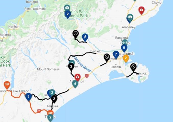
A summary of closed highways in Canterbury as at 5pm today

  • SH73, Springfield to Castle Hill – slips, flooding, bridge approaches washed out in three places, shingle coating the road for 100 metres and one metre thick between Lake Lyndon and Porter River.
  • SH77, the inland route Darfield, Windwhistle to Mt Hutt/ Winchmore – slips and flooding.
  • SH75 the Akaroa highway – closed from Barrys Bay to Birdlings Flat.
  • SH1, south of Christchurch – closed at the Selwyn River/ Waikirikiri, Dunsandel. Water 500 mm deep, should be opened tomorrow/ Tuesday.
  • SH1 remains closed several places through mid to south Canterbury – Hinds to Temuka, water 600 mm deep north of the Hinds River bridge. 
  • SH77 Methven to Windwhistle and Darfield – the inland scenic route – closed due to flooding several places.
  • SH79 –  Rangitata to Geraldine, flooded in several places. 

Up-to-date traffic map

Facebook pages

https://www.facebook.com/HurunuiDistrictCouncil/

https://www.facebook.com/WaimakaririDistrictCouncil/

https://www.facebook.com/ChristchurchCityCouncil/

https://www.facebook.com/AshburtonDC/

https://www.facebook.com/TimaruDC/

Current situation as at 4.30pm, Monday 31 May 

View larger image

Plan ahead for a safe, enjoyable journey. Keep up to date with:

Speed limits are being reviewed on State Highway 51, between Waipatu in Hastings and Marine Parade in Napier, and the winding section of SH5, from Rangitaiki to Esk Valley, in an effort to save lives and prevent serious injuries from crashes along these high-risk roads.

“Improving safety on New Zealand’s road is the top priority for Waka Kotahi. We want everyone who uses our roads to get to where they’re going safely,” Director of Regional Relationships Linda Stewart says.

“Even when speed isn’t the direct cause of a crash, it is the single biggest factor that determines whether a person is killed, seriously injured, or walks away from a crash unharmed. That’s why we are proposing safer speeds for SH5 and SH51, along with safety improvements.”

The consultation and engagement period was extended by four weeks, following concerns about the calculation and presentation of likely travel time increases related to lower speed limits on SH5. The updated travel time information is available on the SH5/51 speed review webpage.

SH5/SH51 Hawke’s Bay speed review webpage

“Consultation for any proposed speed changes is about much more than asking if people are ‘for or against’ the proposal. It’s about seeking valuable and practical input from locals, industry and people who use the road regularly, so that we can consider wider factors and context into our decisions,” Ms Stewart says.

“We’ve been really pleased with the level of engagement from the community on the speed review so far. The feedback will be considered by Waka Kotahi before we make decisions on the proposed speed limit changes.

“For those who haven’t yet had their say, you still have until this Sunday to tell us what you think about proposed speed limit changes for SH51 from Marine Parade to Waipatu, and on the middle section of SH5 from Rangitaiki to Esk Valley.

“We also want to understand how people feel about speeds on SH5 along the Rangitaiki Straights and around Eskdale to help us decide if we should propose new speed limits here in the future too.”

The consultation and engagement period closes at 11pm on Sunday 6 June 2021.

The introduction of safer speeds is part of the Road To Zero strategy developed in partnership with NZ Police, Ministry of Transport, local government and WorkSafe that adopts Vision Zero and sets a target to reduce deaths and serious injuries on New Zealand’s roads, streets, cycleways and footpaths by 40 percent by 2030.

Plan ahead for a safe, enjoyable journey this summer. Keep up to date with:

“The Selwyn River/ Waikirikiri deep flooding on SH1 at Dunsandel means this highway link south of Christchurch is unlikely to open today.

”In north Canterbury rain is continuing and we have a number of areas we need to assess, for example SH73, Porter’s Pass to the West Coast , which will remain closed. 

“Engineers are assessing the two Kowai River bridges and Porter River bridge approaches on SH73 today, and there is a lot of river shingle covering this highway which needs to be shifted before it can reopen.

“The Lewis Pass via Waipara, SH7, the other route linking Canterbury and the West coast, is open.”

People are best advised to avoid travel in Canterbury today given the still changing situation, she says. “Check our traffic and travel map and South Island Facebook page before you head out if you have to do so.

“Many local roads are also under water, so your local council’s Facebook pages and Emergency Management pages are the best places to check.”

A summary of closed highways in Canterbury as at lunchtime today:

  • SH73 Darfield to Castle Hill – slips, flooding, bridge approaches washed out in three places, shingle coating the road for 100 metres and one metre thick between Lake Lyndon and Porter River.
  • SH77, the inland route Darfield to the Rakaia Gorge – slips and flooding.
  • SH75 the Akaroa highway – closed from Barrys Bay to Birdlings Flat.
  • SH1, south of Christchurch – closed at the Selwyn River/ Waikirikiri, Dunsandel. Water a metre deep over the road at this point and not dropping currently.
  • SH1 closed several places through mid to south Canterbury – Hinds to Temuka, water 600 mm deep north of the Hinds River bridge. 
  • SH77 Methven to Windwhistle and Darfield – the inland scenic route – closed due to flooding several places.
  • SH79 Rangitata to Fairlie and Geraldine – flooded in several places.
  • SH8 Fairlie to Tekapo via Burkes Pass, closed due to flooding.

River watches

Ms Forrester noted that crews are watching the Ashburton, Hinds, Orari and Opihi Rivers closely as all are at high levels around bridges. Generally, south of Timaru there are fewer issues.

Hurunui area watch

The Hurunui area and bridges over the Hurunui River are also being watched given the ongoing rain in North Canterbury and the current reliance upon SH7 the Lewis Pass.

Traffic map 

Facebook pages:

https://www.facebook.com/HurunuiDistrictCouncil/

https://www.facebook.com/WaimakaririDistrictCouncil/

https://www.facebook.com/ChristchurchCityCouncil/

https://www.facebook.com/AshburtonDC/

https://www.facebook.com/TimaruDC/

Current situation as at midday Monday 31 May 

Plan ahead for a safe, enjoyable journey. Keep up to date with:

The resource consent for activity at this site is expiring, so the facility must be closed.  

Waka Kotahi NZ Transport Agency Systems Manger Ross I’Anson says Waka Kotahi is currently in the process of developing an alternative, more environmentally sustainable facility for the site.

“We are looking at options for a new facility at Ahititi where effluent can be stored, before being transported offsite to be treated and disposed of.

“This would align with the policy direction of the Taranaki Freshwater Plan,” says Mr I’Anson.

Waka Kotahi is working to have a new facility operational as soon as possible.

An alternative disposal site is located on SH3 in Waverly.

Farmers are encouraged to stand their stock overnight before moving to reduce effluent on the journey.

Plan ahead for a safe, enjoyable journey this summer. Keep up to date with:

All lanes on the Auckland Harbour Bridge as well as the Curran St on-ramp are now open.

Lanes were closed as Police facilitated a group of cyclists who breeched police cordons in order to cross over the bridge.

When notified of the pedestrian activity on the Current St on-ramp which leads to the Auckland Harbour Bridge, Waka Kotahi traffic managers acted quickly in a live traffic environment to close two northbound lanes to create a safe environment and maintain the remaining two northbound lanes.

This caused significant traffic disruption with road users urged to postpone travel or use the alternative western Ring Route (SH16).

Plan ahead for a safe, enjoyable journey. Keep up to date with:

The Curran St onramp is also closed.

A police operation is underway and it could be some time before the incident is cleared and traffic returns to normal.

Delays are expected and motorists are asked to postpone travel or use the alternative Western Ring Route (SH16).

All south bound lanes remain open.

Please take extra care, reduce your speed and follow directions of police, traffic management staff and signage.

Plan ahead for a safe, enjoyable journey. Keep up to date with:

2021 Acura TLXWhat kind of car is the 2021 Acura TLX? What does it compare to? The 2021 Acura TLX is a mid-size premium sport sedan that offers front-wheel drive and torque-vectoring all-wheel drive. It seats five in comfort and exists in a middle space between mainstream sedans and a luxury market dominated by European rivals. In size, competitors include the…

“Please avoid travelling through South and Mid Canterbury and postpone your trips wherever possible on all these routes,” says Tresca Forrester, Journey Manager for Waka Kotahi NZ Transport Agency.

  • SH73 linking the West Coast and Canterbury between Springfield/ Porter’s Pass and Castle Hill due a bridge approach washout and surface flooding is closed.  This route will stay closed overnight and Monday morning at least. Next update midday Monday.  https://www.journeys.nzta.govt.nz/traffic/roadclosures/343640
  • SH79 Fairlie to Geraldine and since this afternoon, back to Rangitata, due to flooding across the highway and at key culverts/bridges is closed. Closure points are at Claytons Road (Fairlie end) and Earl Road (Geraldine end). This closure will be in place overnight. https://www.journeys.nzta.govt.nz/traffic/roadclosures/343665 
  • SH8 through Burkes Pass is likely to close later this afternoon ie Fairlie to Tekapo with culverts constantly filling with debris.  https://www.journeys.nzta.govt.nz/traffic/areawarnings/343613
  • SH77 the inland route Darfield to Methven and Ashburton: Flooding near the Hawkins Bridge. The Selwyn River/ Waikirikiri has breached its banks at Glentunnel and is flowing across SH77 to the south. SH77 has been closed at this point and a detour on local roads is in place. This closure may be extended back to Windwhistle soon.
  • SH1 Dunsandel: Waka Kotahi is closely monitoring the Selwyn River/ Waikirikiri where it crosses SH1 at Dunsandel so please keep an eye on the highways page for changes.
  • SH1 Ashburton at Saunders Road, Netherby, near the Racecourse, has surface flooding, please expect delays through this area.  https://www.journeys.nzta.govt.nz/traffic/roadhazards/343549
  • SH1 south of Temuka: Due to flooding the highway is closed at Arowhenua Road/ the Opihi River.  https://www.journeys.nzta.govt.nz/traffic/roadclosures/343694 

Kaikōura

People planning to travel through Kaikōura on SH1 should check the highway traffic map before heading off. More rain is forecast for later today and it is possible this highway could close overnight.

People can check the traffic map for changes later this afternoon and overnight

Traffic map

“Please check your local councils’ Facebook pages for specific information and avoid travelling along these flooded routes today,” says Ms Forrester.

https://www.facebook.com/TimaruDC/

https://www.facebook.com/AshburtonDC/

https://www.facebook.com/ChristchurchCityCouncil/

2021 Ford Mustang Mach 1What kind of car is the 2021 Ford Mustang? What does it compare to? The Mustang is Ford’s touchstone coupe or convertible. With prosaic turbo-4 or earth-shaking supercharged V-8 power, it blends retro style with modern performance to fend off its long-time rivals, the Dodge Challenger and Chevy Camaro. Is the 2021 Ford Mustang a good car? We…

2021 Jaguar XFWhat kind of car is the 2021 Jaguar XF? What does it compare to? A mid-size luxury sedan, the 2021 Jaguar XF competes with mostly European rivals such as the Audi A6, BMW 5-Series, Mercedes-Benz E-Class, and Volvo S90. It lacks high-performance and hybrid versions like many of those cars, and it no longer offers a wagon body style. Is the 2021…