District:
Southern
The road has now reopened following a serious crash at the intersection of Hanover Street and Castle Street in Dunedin thir morning.
ENDS
Issued by Police Media Centre
District:
Police advise there will be delays on the Dunedin Southern Motorway this morning after a vehicle collision.
A truck has collided with the central barrier and has damaged a large stretch of the barrier.
Traffic flow will be affected in both directions as crews work to clear the debris and we urge motorists to be patient.
The driver of the truck has been taken to hospital.
ENDS
Issued by Police Media Centre
District:
Police are responding to a serious crash on the intersection of Hanover Street and Castle Street.
Two trucks have collided and one person has been seriously injured.
Traffic will be diverted through Frederick Street while emergency services attend the scene.
ENDS
Issued by Police Media Centre
 What kind of vehicle is the 2022 Chevy Tahoe? What does it compare to? The Tahoe is Chevy’s three-row, nine-seat SUV that isn’t a Suburban. It’s shorter than that mammoth utility vehicle, but it’s still a massive vehicle that compares to vehicles like the Ford Expedition and GMC Yukon. Is the 2022 Chevy Tahoe a good SUV?…
“Drivers will be allowed through every two hours overnight and emergency vehicles will be accommodated at all times,” says Waka Kotahi Journey Manager Tresca Forrester.
The work will run from Sunday, 5 December through to Thursday night, 9 December, 7pm to 6am the next day. Weld Pass is a winding section of SH1, halfway between Blenheim and Seddon.
Drivers will be allowed through every two hours, with a ten to 15-minute window for single lane traffic each way.
After the 7pm closure, the first opening will be at 9pm, then 11pm, 1am, 3am and 5am. Full opening at 6am.
“Waka Kotahi thanks all drivers who may be inconvenienced and encourage everyone to plan for the opening times if they can. Traffic will be queued at each end between opening times.
“We encourage people who have ferries booked to ensure they factor in these delays south of Picton if they are leaving in the evening,” says Ms Forrester.
Electronic signs will advertise the closures at each end ie near Blenheim at the Roadhouse entry and in Seddon as well as fixed signs in other places.

Location of closures along SH1 at Weld Pass
Plan ahead for a safe, enjoyable journey. Keep up to date with:

SH1/Loop Road intersection
The final 50mm of asphalt is what provides a smoother journey for motorists and will be laid on each approaching road, extending up to 150m from the roundabout.
The night works will take place between 7pm and 6am on the following dates:
A temporary speed limit of 30km will be in place and motorists are urged to take care and follow all signage.
Please note this work may be rescheduled due to the weather or COVID-19 restrictions. New dates and times will be communicated in the event of a postponement.
Waka Kotahi thanks road users for their cooperation and understanding while we carry out this work.
Finishing works to complete the project will be carried out after the busy New Year period.
Plan ahead for a safe, enjoyable journey. Keep up to date with:

Map showing area of works
To prepare for the daytime works, a full closure of State Highway 1 (SH1) southbound between Greville Road and Constellation Drive will be required overnight on Saturday 27 November and Sunday 28 November to install and remove temporary lane barriers. Detour routes will be available.
The restrictions will apply during the following times:
Overnight full closure:
Day works – lower speed limit in place:
Overnight full closure:
During the daytime works temporary lane barriers will be used to detour vehicles around either side of the work area, with a 50kmph speed limit in place.
The team will be completing a concrete pour on the future SH1/SH18 underpass and need to ensure vibrations from passing vehicles is kept to a minimum.
Waka Kotahi encourages drivers to plan ahead and avoid the Albany and Rosedale area if possible.
For people who need to travel through the area, Waka Kotahi advises drivers to choose their lane much earlier than usual and look out for messaging on overhead and electronic signs.
Motorists who want to exit SH1 at Constellation Drive will need to use the left lane only.
An express lane to the right of the work area will also be operating for people wanting to continue their journey south towards the city.
Drivers will not be able to exit State Highway 1 at Constellation Drive if they are in the right-hand lane.
We understand the expected delays will be frustrating for drivers, but due to the preparation needed, crew were unable to undertake this work during higher Alert Levels.
Waka Kotahi also advises that two weekends will be needed to complete this work, with the same restrictions in place across the weekend of December 5.
Weekend two
Overnight full closure:
Day works – lower speed limit in place:
Overnight full closure:
It’s important the NCI team are able to complete the work now, to minimise disruption ahead of the opening of Auckland’s borders and the busy summer months.
When complete, the underpass will provide a direct motorway to motorway connection for people travelling from the north and wanting to head west, completing the Western Ring Route.
For more information visit:
Plan ahead for a safe, enjoyable journey. Keep up to date with:

Artists impression of the bridge
Construction has now started on the arch, which is the main architectural feature of the new walking and cycling link over the Manukau Harbour connecting Auckland’s southern and north western suburbs.
“Building over water is always a challenge, but this project is made more complex by the addition of the steel central deck and arch,” says Mark Kinvig, Waka Kotahi National Manager Infrastructure Delivery.
“A team of highly skilled engineers, designers, truck and crane operators as well as riggers and ground staff are needed to help guide the six pieces which make up the arch and central deck into place.”
The arch and central deck were fabricated in Napier in 21 smaller pieces before being transported up to the project yard. Once there, the team have spent months welding the pieces together to create three large deck sections each weighing approximately 110 tonnes and three arch sections weighing 28 tonnes each.
“The components will be taken by a heavy lift truck and trailer onto the temporary staging, where two cranes will work in tandem to lift each section separately into place. The whole process will take several months to complete,” says Mark Kinvig.
In addition to the temporary supports already in place to support the bridge deck, two more will be built between the two large piers to help carry the weight of the arch as the pieces are slowly linked together. (See graphic below)
“Months of planning has gone into this part of the project and we are grateful to have some of Auckland’s sharpest minds working on it. Strict health and safety protocols are in place as we’re not only working across both land and sea, but under high voltage transmission lines. There’s also the added complexity of ensuring we do all of this while meeting COVID-19 health and safety guidelines.”
The architecturally designed bridge will not only provide a way for people to cross the harbour on foot or by bike, but it’s hoped will become a destination in itself.
At 8-metres wide, it has space for two fishing bays and bench seating for people to sit and enjoy the harbour views. The new bridge will also provide increased clearance underneath and space between the piers for waka, canoes and small watercraft to travel to and from the Māngere Inlet.”
“When completed, the bridge will become an iconic feature of Auckland’s skyline and I know those working on this project are really proud of constructing a place for the community to connect.”
Despite disruptions due to COVID-19, progress on the new bridge is tracking well and is expected to open in late 2022.
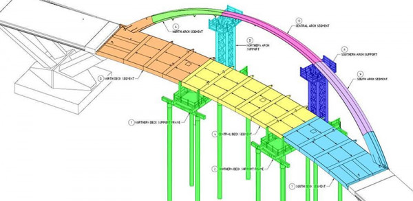
Bridge design showing segments and supports
Plan ahead for a safe, enjoyable journey. Keep up to date with:
From 1 December 2021 the five-year limit, the requirement to sit a theory test at renewal and the 90-day restriction on renewal will be removed from learner and restricted driver licences.
New Zealand’s driver licence system has three progression stages – learner, restricted and full licence –to manage the crash risk of drivers learning to drive, with minimum time periods to be completed before a driver can apply to progress through to the next stage.
“Despite efforts to encourage drivers to progress through the licence stages within five years drivers have not moved to a higher stage for valid reasons, and this has had no clear benefit or impact on road safety,” says Waka Kotahi’s Director of Land Transport Kane Patena.
“These changes make all stages of licence valid for 10 years and will allow drivers to gain the skills and confidence to progress to the next licence stage at their own pace or stay at their licence stage if they choose to.”
“Feedback gathered during consultation confirmed that the changes will make licensing more accessible and remove cost, stress and anxiety from drivers on learner and restricted licences wanting to stay at their stage of licence or advance in their own time,” Mr Patena says.
These changes will also help alleviate pressure on the driver licensing system that has a backlog of licence renewals due to COVID restrictions and is expecting approximately 3,000-5,000 licence holders a month will apply to have their learner or restricted licence renewed between now and late 2023.
Waka Kotahi NZ Transport Agency consulted, on behalf of the Minister of Transport, on Land Transport (Driver Licensing) Amendment Rule (No 2) 2021 between 13 September and 8 October 2021.
After considering all the feedback, Waka Kotahi concluded there were no additional unanticipated risks arising from the proposals and the changes would ensure our legislation is sound and working for us all.
Plan ahead for a safe, enjoyable journey. Keep up to date with:
Thanks to Government funding from the NZ Upgrade Programme Canterbury package, up to $90 million is available to make Brougham St (SH76) safer and easier to use for the surrounding communities and its many different road users.
NZ Upgrade Programme Canterbury package
“We have a fantastic opportunity to upgrade this busy road, to improve safety, support more transport choices and make it a more reliable freight route to the Port of Lyttelton,” says Director Regional Relationships for Waka Kotahi James Caygill.
“The changes we’re proposing are relatively simple but they will be effective. They will make use of the existing road space to provide more reliable travel times at peak hours, encourage people to walk or bike on a new, safe shared path and build a pedestrian overbridge to get across Brougham Street, between Collins and Simeon Streets.”
The project has already benefited from road users’ and residents’ input and ideas. “Local people have helped shape this plan, but we’d like to check in one more time before we move to final design and construction,” says Mr Caygill.
Feedback is open now until Friday, 28 January 2022.
Video of the Brougham Street upgrade:
Map of the project area:

Key changes Waka Kotahi is proposing include:
See the full list of proposed changes
We’ll be taking feedback until January 28, 2022. People can:
Community open days:
Plan ahead for a safe, enjoyable journey. Keep up to date with: