These works are part of the Waka Kotahi road maintenance programme to repair and reseal state highways across the Bay of Plenty to ensure the safety and resilience of the transport network.

Asphalt resurfacing on State Highway 2

  • Sunday 21 and Monday 22 November
    Night work will take place between Mirrielees Road and the Tauranga Harbour Marina in the eastbound lanes between 7pm and 5am, finishing 5am Tuesday morning.
    One lane will be open during working hours, with a 50km/h temporary speed limit in place.
    Both lanes will be open between 5am and 7pm under a 50km/h temporary speed limit.
  • Tuesday 23, Wednesday 24 and Thursday 25 November
    Night work will take place between Tasman Quay and the Tauranga Harbour Marina, in both directions.
    Work will be between 7pm and 5am, finishing 5am Friday morning.
    One lane will be open during working hours, with a 50km/h temporary speed limit.
    Both lanes will be open between 5am and 7pm under a 50km/h temporary speed limit.

Chipsealing on State Highway 2, State Highway 29 and State Highway 36

Night works will be completed between 7pm and 5am under Stop/Go traffic management and a 30km/h temporary speed limit.

Expect delays of up to 25 minutes for 36 to 48 hours following the work.

For at least 24 hours after the sites are sealed, and before being swept, they continue to operate under a reduced temporary speed limit while vehicles travel over the seal and help “bed in” the chip. This helps reduce the risk of windscreen damage. Sites are then swept, excess chip removed, and the temporary speed limit remains in place until line marking is reinstated (within 48 hours, weather dependent).

  • Sunday 21 November and Monday 22 November
    State Highway 36 Pyes Pa, between Taumata Road and Oropi Road
    State Highway 29, between Poripori Road and McLaren Falls Road
  • Tuesday 23 November
    State Highway 29, between McLaren Falls Road and Soldiers Road
    State Highway 36 Pyes Pa, between Williams Road and Oropi Gorge Road
  • Wednesday 24 November
    State Highway 29, between Soldiers Road and Valley View Road
  • Thursday 25 November
    State Highway 2, between Wilson Road North and Mends Lane
  • Friday 26 November
    State Highway 2, Barrett Road to Munro Road
    State Highway 36 Pyes Pa, between Joyce Road and Oropi Gorge Road.

Motorists are asked to take extra care when travelling through the site and follow directions of traffic management staff and signage.

Waka Kotahi is also reminding people of partial overnight closures of SH29 over the Kaimai Range for essential maintenance on the Waikato side, beginning Sunday night and expected to take three weeks. This will coincide with the chipsealing works on SH29 mentioned above. More details can be found here:

SH29 Kaimai Range partial overnight closure from Sun 21 November

In the event of bad weather or other unforeseen circumstances, work may be postponed.

Visit the interactive Waka Kotahi Journey Planner website for the latest information on roadworks, traffic, road closures and detours to help plan your trip.

Journey Planner

Waka Kotahi thanks motorists for their patience.

Plan ahead for a safe, enjoyable journey. Keep up to date with:

These works are part of the Waka Kotahi spring/summer road maintenance programme, which will see repairs and resurfacing carried out on state highways across the Bay of Plenty.

The works comprise of eight chipseal sites on State Highway 30, between the State Highway 1 intersection at Ātiamuri and State Highway 5 intersection and will take place between 7am and 5pm.

The sites will operate under Stop/Go traffic management with a 30km/h temporary speed limit in place during the work.

It is important motorists adhere to the relevant temporary speed limits during these works to ensure their safety and that of other road users and road workers, and avoid damage to their vehicles.

Motorists are advised to expect delays of up to 15 minutes the day after works.

For at least 24 hours after a site has been sealed, and before it is swept, it continues to operate under a reduced temporary speed limit of 50km/h while vehicles travel over the seal and help “bed in” the chip and to reduce the risk of chip damaging windscreens. The site is then swept, excess chip is removed, and the temporary speed limit remains in place until line marking has been reinstated (within 48 hours of the site being sealed, weather dependent).

Waka Kotahi thanks motorists for their patience.


Plan ahead for a safe, enjoyable journey. Keep up to date with:

Tie-in works for the Hamilton section will require detours off the Ngāruawāhia section between Tuesday 23 November and Friday 26 November, with Sunday 28 November and Monday 29 November as contingency dates.

In a departure from earlier plans, the detour is being split with southbound traffic first then northbound.

The detour is the former state highway route (Great South Road) through Ngāruawāhia from the Horotiu and Taupiri interchanges between 7pm and 6am.

Southbound:

  • Tuesday 23 November
  • Wednesday 24 as a contingency date

Northbound

  • Wednesday 24 November
  • Thursday 25 November
  • Friday 26 November
  • Saturday 27 November – no work, no detours
  • Sunday 28 November contingency date
  • Monday 29 November contingency date

The detour means High Productivity and Over-Dimension vehicles will need to use State Highway 26 and State Highway 1B due to the weight restriction at Ngāruawāhia’s town bridge.

A second detour, at Ohinewai, will now occur from Sunday 12- Friday 17 December, when southbound traffic will be detoured off the Ohinewai section while temporary barriers are removed.

All southbound traffic will be detoured from Rangiriri to the Glen Murray bridge, along Te Ohaki Road and across the Tainui Bridge at Huntly between 7pm and 7am.

The Ohinewai detour involves the single-lane Glen Murray bridge, which is weight restricted. A detour route via Waikato District Council local roads will be in place for General Access vehicles. It can be used by Overweight Vehicles provided they hold a permit for the route from Waikato District Council.

Vehicles without permits to use the detour (such as Overweight, 50MAX, HPMV and Over Dimension) may use State Highway 2 and State Highway 27, provided they hold the relevant permits.

All other heavy vehicles are not permitted to use the detour or alternative route and will need to plan their journeys for outside the closure times.

Visit the interactive Waka Kotahi Journey Planner website for the latest information on roadworks, traffic, road closures and detours to help plan your trip.

Journey Planner website

Waka Kotahi NZ Transport Agency thanks motorists for their patience.

Plan ahead for a safe, enjoyable journey. Keep up to date with:

Contractors will be following strict industry standards provided by Construction Health and Safety NZ (CHASNZ) to ensure the safety of workers and road users. People must maintain safe physical distancing of two metres when walking/cycling near the sites. 

Some delays are expected at times, and motorists are advised to plan and allow extra time for their journeys. There may be an increase in people walking and cycling around the site, so please be careful when driving near them.

Work sites for the week starting Sunday 21 November: 

  • State Highway 30, Puarenga Bridge underpass: The Puarenga Bridge underpass is open with pedestrians and cyclists advised to take care as contractors continue with landscaping works through this area.
  • State Highway 30, Puarenga Bridge: Contractors will continue with landscaping on both sides of the Puarenga Bridge. This work will require shoulder closures in both directions and is not expected to cause delays.
  • Tarawera Road: Contractors continue work on the watermain upgrade. This work will require shoulder closures in both directions but is not expected to cause delays.
  • State Highway 30, Tarawera Road to Neil Hunt Park: Contractors continue to prepare for footpath work. This will require a lane shift for traffic which may cause minor delays.
  • State Highway 30, east of Puarenga Bridge to Tarawera Road: Contractors continue landscaping the berms on the southern side of SH30/Te Ngae Road between Tarawera Road intersection and Puarenga Bridge. Lane closures in both directions will be in place during off-peak times, which may cause moderate delays.
  • State Highway30, Marino Road: Signalised pedestrian crossings are now open and operational across Tarawera, Te Ngae and Marino Roads. Contractors continue work on the footpath and seating area at the corner of Marino Road. This work will require eastbound off-peak lane closures, which may cause minor delays.
  • State Highway 30, Allen Mills Road to Iles Road: Contractors continue with landscaping in the centre median, which requires both eastbound and westbound right-hand lane closures and may cause moderate delays.
    Contractors continue work on the retaining wall and rain gardens on the northern side of SH30/Te Ngae Road. This work requires eastbound lane closures during off-peak hours, which may cause moderate delays.
    The installation of street lights and footpath work on the southern side of SH30/Te Ngae Road between Allen Mills Road to Iles Road continues. Access for people walking and cycling will be maintained with traffic management in place. This work will be done under westbound off-peak lane closures and may cause moderate delays.
  • State Highway 30, Brent Road, Tumene Drive and Tennyson Drive intersection: Contractors continue works on the footpath at Tennyson Drive, this work will be done with a lane shift which may cause minor delays.

Temporary speed limits of 30km/h or 50km/h are in place for everyone’s safety at the above work sites, including when workers are off-site. 

All pedestrian crossings at the SH30/Te Ngae Road and Tarawera Road intersection are now open, providing safe crossing points. People walking and cycling are encouraged to use the signalised crossings at Sala Street, Iles Road, Marino Road and Tarawera Road. 

Most of the shared path is now open and works are underway to complete the last sections of the shared path on the northern side of Te Ngae Road between Marino and Iles roads.

Access for people walking and cycling is maintained throughout the whole site. 

In the event of bad weather or other unforeseen circumstances, work may be postponed.


Plan ahead for a safe, enjoyable journey. Keep up to date with:

Check daily updated closure information

Unless otherwise stated, closures start at 8pm and finish at 5am.

NORTHERN MOTORWAY (SH1)

  • Orewa northbound on-ramp, 25-26 November
  • Orewa northbound off-ramp, 25-26 November
  • Northbound lanes between Oteha Valley Road off-ramp and Silverdale on-ramp, 21-22 November (approx. 10:00pm to 5:00am)
  • Oteha Valley Road northbound on-ramp, 21-22 November
  • Southbound lanes between Greville Road off-ramp and Upper Harbour Highway on-ramp, 21 & 27 November (approx. 9:00pm to 5:00am)
  • Greville Road southbound on-ramp, 21 & 27 November
  • Upper Harbour Highway southbound off-ramp, 22-25 November
  • Northbound lanes between Northcote Road off-ramp and Tristram Avenue on-ramp, 22-25 November (approx. 10:00pm to 5:00am)
  • Northcote Road northbound on-ramp, 22-25 November
  • Stafford Road northbound off-ramp, 21-25 November (approx. 10:00pm to 5:00am)
  • Shelly Beach Road southbound off-ramp, 23 November (approx. 9:30pm to 5:00am)
  • Curran Street northbound on-ramp, 21-25 November

CENTRAL MOTORWAY JUNCTION (CMJ)

  • Eastbound lanes between Wellesley Street East off-ramp and Grafton Road on-ramp, 25 November (approx. 10:00pm to 5:00am)

SOUTHERN MOTORWAY (SH1)

  • Khyber Pass Road southbound on-ramp, 25 November
  • Khyber Pass Road northbound off-ramp, 21-24 November
  • Princes Street southbound off-ramp, 24 November
  • Northbound lanes between Drury/SH22 off-ramp and Papakura on-ramp, 21-25 November (approx. 9:00pm to 5:00am)
  • Drury/SH22 northbound on-ramp, 21-25 November

NORTHWESTERN MOTORWAY (SH16)

  • Te Atatu northbound on-ramp, 25 November
  • Great North Road westbound off-ramp, 22 November

UPPER HARBOUR MOTORWAY (SH18)

  • None planned

SOUTHWESTERN MOTORWAY (SH20)

  • Northbound lanes between Hillsborough Road off-ramp and Maioro Street on-ramp, 25 November (approx. 10:00pm to 5:00am)
  • Dominion Road northbound on-ramp, 25 November
  • Hillsborough Road northbound on-ramp, 25 November
  • Rimu Road southbound off-ramp, 24-25 November
  • Walmsley Road southbound on-ramp, 25 November

GEORGE BOLT MEMORIAL DRIVE (SH20A)

  • None planned

PUHINUI ROAD (SH20B)

  • None planned

STATE HIGHWAY 22 (SH22)

  • None planned

STATE HIGHWAY 2 (SH2)

  • None planned


Please follow the signposted detours. Waka Kotahi thanks you for your co-operation during these essential improvements and maintenance.

To check for the most current overnight closure information please visit www.nzta.govt.nz/traffic/auckland before you leave.

Auckland roads and public transport: www.at.govt.nz

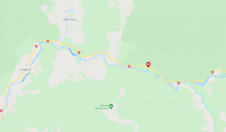
From Monday, 22 November through to Wednesday, 22 December Waka Kotahi will be working at an area* between the Owen River Bridge and Kawatiri Bridge.

“Scaling and rock removal work is needed after a recent slip in late October, to stabilise the rock face,” says Andrew James, System Manager Waka Kotahi Top of the South. “We want to return the highway to two lanes in time for the Christmas traffic.”

Work will be under way Monday to Saturday, 7am – 6pm. Outside these hours the site will be managed with temporary traffic signals with the single lane and a 30km/hour speed limit.

While the scaling works are taking place, the site will be managed by Stop/Go traffic management with most delays between 10 and 15 minutes. There will also be slightly longer closures up to 30 minutes.

Contractors, using helicopters, will be drilling, scaling/ removing rocks and installing netting over the rockfall area.

Waka Kotahi thanks road users for their patience in the lead up to Christmas.

The aim is to get this site back to two lanes for the summer break with further rockface safety work to take place in the New Year, says Mr James.

*The area is called Granity Narrows or Granity Rapids by local people.

The red spot in the middle of the map to the east of the Owen River is where this slip remediation work is happening.

Updates on this work here:

SH 6 Between Owen River Bridge and Kawatiri Bridge (Granity Narrows) live update 


How the road south of Nelson, on SH6, Tasman District, looked last week.


Plan ahead for a safe, enjoyable journey. Keep up to date with:


District:

Counties Manukau

Emergency services are responding to a three-vehicle crash on Reagan Road.

One person is reported to have serious injuries.

The road is blocked near the crash site and cordons are in place.

Motorists are asked to avoid the area.

ENDS

Issued by Police Media Centre

The programme was paused in October after parts of the Waikato moved into Covid-19 Alert Level 3. The sealing crews were based in areas that were in Level 3, so the work was postponed to avoid risk to communities still in Level 2.

Crews will start working on SH25 in Thames on Monday, before working their way clockwise around the Coromandel on SH25A then SH25, with work paused during the busy Christmas-New Year period.

For more details about  the Coromandel summer chipsealing programme, check out the previous media release on our website:

Getting Coromandel state highways sealed for summer (20 October 2021)

For information about roadworks and maintenance on Waikato state highways this summer, visit:

Journey Planner


Plan ahead for a safe, enjoyable journey. Keep up to date with:

Waka Kotahi NZ Transport Agency is renumbering the section of State Highway 1 (SH1) between Linden and Mackays Crossing as State Highway 59 (SH59), in advance of the opening of the new Transmission Gully motorway, which will become SH1.

“We’re doing a huge amount of work to prepare the state highway network for the opening of Transmission Gully – including additional CCTV, new signage, and encouraging good driving behaviour – and the SH59 renumbering is a key part of that,”says Mark Owen, Regional Maintenance and Operations Manager.

“Renumbering this section of state highway now allows us to be ready for opening, and for people to start getting used to the new number.”

State highway signage throughout the region will be updated to reflect the change and Waka Kotahi is also working with map providers so that navigation systems can be updated.

“Being able to refer to SH59 will mean we can clearly communicate when there is an incident or crash, help people find their way around the network, and reinforce the understanding that the new SH1 via Transmission Gully will be the primary route in and out of the region,” says Mr Owen.

Despite the change in state highway number the route will remain the same and people will continue to use the road as normal, until Transmission Gully opens.

When the new motorway opens it will become SH1. In the meantime, the renumbering to SH59 will create a small break in SH1.

State highways are numbered according to which part of the country they are located. State highways within the Wellington, Manawatū and Hawke’s Bay regions are numbered between 50-59, with 59 being the next available number for the Wellington region.

View renumbering Wellington SH1 and SH59 maps


Plan ahead for a safe, enjoyable journey. Keep up to date with:

Waka Kotahi NZ Transport Agency is moving to make state highways in Hamilton City safer, with new speed limits in place from next month.

State Highways 1, 3 and 26 are crucial roads through the Waikato’s largest city, and there have been calls to make these roads safer by reducing the speed for some time. Between 2009 and 2018 there were 1,311 reported crashes on these roads, with 10 people killed and 61 seriously injured.

Waka Kotahi has reviewed what the safe and appropriate speeds should be and the legal process to change the speed limits will be completed on 10 December, with signs installed soon after. Once the signs are in place, drivers will be required to comply with the new speed limits.

Director of Regional Relationships David Speirs says there are a number of factors that go into setting safe and appropriate speeds.

“We looked at the number of people who use these roads and the various ways they use them, as well as the features of the roads and the surrounding environment. These city highways are high-volume with pedestrians and cyclists mixing with general traffic.

“A small reduction in speed makes a big difference in the outcome of crashes. It determines whether anyone is killed, injured or walks away unharmed.”

Waka Kotahi has reviewed what the safe and appropriate speeds should be and the legal process to change the speed limits will be completed on 10 December. The signs will be installed as soon as possible following this date, and it will take some time, including working at night, to install the large number of signs.  Once the signs are installed, drivers will be required to comply with the new speed limits.

The following table shows the confirmed speed limits:

State highway

SH1, SH3, SH26, Hamilton City

Existing speed limit

New speed limit

SH1

From 180m north west of the centre of the Crawford Street / Avalon Drive / SH1 Roundabout to 250m north of Rifle Range Road (existing speed limit change point)

80km/h

60km/h

SH1

From 150m south of Killarney Road (existing speed limit change point) to 70m north of Kahikatea Drive (SH1) (existing speed limit change point)

80km/h.

60km/h

SH1

From 41m east of Alison Street (proposed new speed limit change point) to 70m north-east of Lorne Street (existing speed limit change point)

60km/h

50km/h

SH3

From the Kahikatea Drive intersection (existing speed limit change point) to 25m south-east of Resthill Crescent (existing speed limit)

60km/h

50km/h

SH3

On Normandy Avenue (SH3) from SH1, Lorne Street (existing speed limit change point) to SH3 Ohaupo Road (existing speed limit change point)

60km/h

50km/h

SH1

From 70m north-east of Lorne Street (existing speed limit change point) to 190m west of Howell Avenue (existing speed limit change point)

80km/h

60km/h

SH1

From 190m west of Howell Avenue (existing speed limit change point) to 70m south of Riverlea Road (existing speed limit change point)

60km/h

50km/h

SH26

On Morrinsville Road (SH26) from SH1 (existing speed limit change point) to 260m north-east of Berkley Avenue (existing speed limit change point)

60km/h

50km/h

SH26

Berkley School VSL
105m north east of Cambridge Road to30m south west of Berkley Avenue

60/40km/h

50/40km/h

SH3

From 25m south-east of Resthill Crescent (existing speed limit change point) to 265m south of the centre of the new SH3 Ohaupo Road / Southern Links roundabout (new speed limit change point)

70km/h

60km/h

SH3

From 265m south of the centre of the new SH3 Ohaupo Road / Southern Links roundabout (new speed limit change point) to 340m north of Rukuhia Road (existing speed limit change point)

100km/h

80km/h

SH3

Intersection Speed Zone Ohaupo Road (SH3)/Raynes Road

Expected to be implemented mid 2022

100km/h

80/60km/h

“We had a lot of feedback from people asking for safety improvements to be made at the intersection between Raynes Road and SH3/Ohaupo Road, as they didn’t feel safe pulling out of Raynes Road onto the highway,” Mr Speirs says.

“The new speed limit through this section of SH3 will be 80km/h and we will be putting in an intersection speed zone (ISZ). This is expected to be completed in mid-2022, and it will mean the speed limit will temporarily reduce to 60km/h when the electronic signs detect someone turning in or out of Raynes Road.”

Planning is also underway to upgrade the T-intersection at the Raynes Road/SH1 intersection to a roundabout to further improve safety. Waka Kotahi is currently undertaking the feasibility study, and it is hoped this can then move on to construction within the next one to two years. The ISZ will remain in place until the roundabout is fully operational.

The setting of the permanent speed limits follows engagement with the Police, the AA, Hamilton City Council and road user groups, and consultation with the public.

“We thank all those who provided their feedback on the proposed speed limits. There were many suggestions for other ways to improve the safety of these routes and we are looking into opportunities to implement more safety improvements.”

More information on the permanent speed limits and our consultation summary, including the submissions, can be found at:

Hamilton City SH1, SH3 and SH26 new permanent speed limits